


North Carolina DOT has a website that you can search all secondary roads in the state by number or street name.
Secondary Roads Database Lookup
Entering 1192 provides the following list.
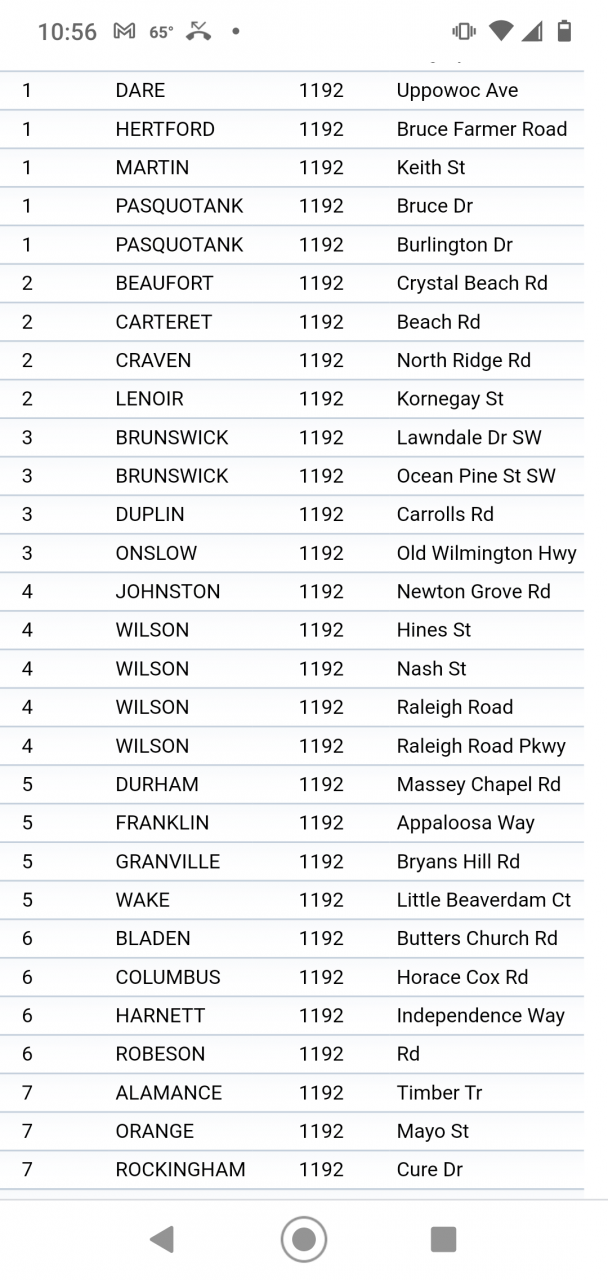
What confuses it is Raleigh Road Pkwy and Hines is actually Alt & Bus. US-264. Could be a clueless state employee who issued the permit.
What's the best map to use for routing?
Discussion in 'Heavy Haul Trucking Forum' started by cburch21, Jan 30, 2021.
Page 2 of 2
-
-

Trucking Jobs in 30 seconds
Every month 400 people find a job with the help of TruckersReport.


-
Yeah pa seriously sucks like that. Try getting direction to a frac or drilling site and you'll get 3 diff sets of directions. One will be SR XXX the other would have the street name Lol and the other set would be from the guys on location. That was the most accurate Lolfarmerjohn64 and cke Thank this.
-
The only time I touch my atlas is to mark of a state in the front when I visit it for the first time.
google maps, google web search usually leading to Wikipedia, and common sense are what I use to find those hard to find routes on permits.
I don’t have a truck specific gps, I use google maps on my phone if necessary, it’s a tool like anything else, you shouldn’t follow it blindly.cke Thanks this. -
Rollr4872, cburch21, black_dog106 and 1 other person Thank this.
-
Google maps and the satelite, will get you trouble, will send you down a dead end road.
cke Thanks this. -
How? Does google maps drive your truck or do you? Everyone that says “an atlas is the only way to route a truck” is behind in the times.
I’ll be heading out in the morning at 15’11” wide and 100’ overall with the wide part at the end of a 70’ double drop stretch.
Because I went turn by turn over my route with google maps satellite view I know I will probably have to wrong way this left hand turn in Kirby, Ar to stay on us 70. The signs will make it to tight with the island layout. What atlas could I have found that information in?shawnhhllc, black_dog106 and Landincoldfire Thank this. -
I understand his point here. A professional uses all the tools provided.
Besides the one bridge on 40 west of Nashville. Arkansas is the most scenic route of our trips to south Texas.shawnhhllc and cke Thank this. -
-
Had a state atlas for all the frequently traveled states


Trucking Jobs in 30 seconds
Every month 400 people find a job with the help of TruckersReport.

Page 2 of 2